Volcano Safety Guide
Essential information for staying safe around Iceland's active volcanoes — alert systems, emergency procedures, and what to do when nature acts up.
Always Check Before You Go
Check vedur.is for eruption status before visiting active volcanic zones. Never approach lava flows without a licensed guide. Toxic gases and unstable ground are constant hazards near active vents.
Current Volcanic Alert Levels
Status as of February 2026 — always verify at vedur.is for live updates.
Reykjanes Peninsula
ORANGEHeightened unrest with ongoing seismic activity and ground deformation. Eruption possible.
Katla
YELLOWElevated unrest above background levels. Increased monitoring in place.
Hekla
GREENNormal background activity. Regular monitoring continues.
Grímsvötn
YELLOWElevated activity with gradual buildup towards next eruption.
Iceland's Volcanic Alert System
GREEN — Normal
- Background volcanic activity
- No signs of unrest
- Standard monitoring continues
- No restrictions for tourists
YELLOW — Advisory
- Elevated unrest above normal
- Increased earthquake activity
- Ground deformation detected
- Enhanced monitoring activated
- Tourist areas remain open
ORANGE — Watch
- Heightened unrest with escalating activity
- Eruption likely within weeks to months
- Possible access restrictions
- Emergency services on heightened alert
- Tourist areas may have limitations
RED — Warning
- Eruption imminent or in progress
- Immediate threat to life and property
- Evacuation orders may be issued
- Flight restrictions in effect
- Tourist access prohibited in danger zones

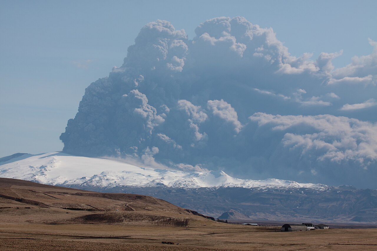
Respect the Power of Volcanoes
Iceland's volcanic eruptions can be spectacular, but they demand respect. Active lava flows, toxic gases, and sudden explosions make volcanic zones inherently dangerous for unprepared visitors.
Always check current alert levels before traveling near active volcanic areas, and never cross safety barriers regardless of how close others may appear to be.
Emergency Procedures
🚨 During a Volcanic Eruption
Stay calm and assess the situation
Don't panic. Most eruptions in Iceland are effusive, not explosive.
Follow official evacuation orders
If authorities order evacuation, leave immediately. Don't delay.
Avoid low-lying areas
Stay away from valleys where toxic gases can accumulate.
Protect yourself from ash
Cover nose and mouth. Volcanic ash causes respiratory problems.
🌪️ Volcanic Ash Exposure
Immediate Actions
- — Seek shelter indoors immediately
- — Close all windows and doors
- — Turn off ventilation systems
- — Wear N95 masks or wet cloth over face
- — Avoid driving unless absolutely necessary
Health Risks
- — Respiratory irritation and breathing difficulties
- — Eye irritation and tearing
- — Especially dangerous for people with asthma
🌊 Glacial Floods (Jökulhlaup)
Warning Signs
- — Sudden increase in river water level
- — Water becomes muddy or carries debris
- — Strange chemical smell
- — Rumbling sounds
Safety Actions
- — Move to higher ground immediately
- — Never try to cross swollen rivers
- — Stay away from riverbanks
- — Alert others in the area
💨 Volcanic Gas Exposure
Dangerous Gases
- CO₂ Heavy, accumulates in low areas
- SO₂ Acid gas, causes breathing problems
- H₂S "Rotten egg" smell, toxic even in small amounts
- Fluorine Highly toxic to livestock and humans
Protection
- — Stay upwind of volcanic vents
- — Avoid valleys and depressions
- — Move to higher, windward areas
- — Seek medical attention if breathing problems develop
How Iceland Monitors Volcanoes
Iceland operates one of the world's most advanced volcano monitoring systems, combining multiple technologies to detect volcanic unrest and predict eruptions.
Seismic Monitoring
Network of 70+ seismometers detect earthquake swarms that precede eruptions, down to magnitude 0.5.
GPS Deformation
Continuous GPS stations measure millimeter-scale ground movement from magma intrusion.
Gas Monitoring
Chemical analysis of SO₂, CO₂, and H₂S reveals changes in magma depth and composition.
InSAR Satellite Radar
Satellite interferometry detects regional ground deformation and glacier thickness changes.
Thermal Cameras
Infrared cameras monitor temperature changes and lava flow movement in real time.
Hydrological Monitoring
River level and conductivity monitoring for early jökulhlaup (glacial flood) detection.
Icelandic Met Office (IMO)
Primary volcanic monitoring and official warnings. Operates the national seismic network.
vedur.is →University of Iceland
Research and scientific analysis. Operates additional monitoring equipment.
Emergency Management Agency
Coordinates emergency response and evacuation procedures during volcanic crises.

Námaskarð geothermal area near Lake Mývatn — ground temperature can exceed 100°C just centimetres below the surface. Stay on marked paths.
Personal Safety Preparation
Essential Apps & Resources
SafeTravel.is App
Official safety information and current warnings
112 Iceland App
Emergency app with GPS location sharing
Vedur.is
Live volcanic monitoring and alerts
Local Radio (RÚV)
Broadcasts emergency info in multiple languages
Emergency Kit Essentials
N95 or P100 face masks
Protect against volcanic ash inhalation
Goggles
Eye protection from ash particles
Battery-powered radio
Stay informed during power outages
3-day supply of water & food
Sustain yourself during an emergency
Emergency Contacts
Emergency Services: 112
Police, fire, medical emergency, search & rescue
ICE-SAR: 570 5900
Icelandic Search and Rescue Association
Tourist Hotline: 1717
General information and assistance for tourists
Your Embassy
Know your country's diplomatic contact in Iceland
Before You Travel
Check current alert levels
Visit vedur.is before any volcano trip
File a travel plan
Register at safetravel.is
Travel insurance
Ensure it covers natural disasters
Research evacuation routes
Know how to get out of your destinations
Regional Volcanic Hazards
🔥 Reykjanes Peninsula
High ActivityCurrent Hazards
- — Active fissure eruptions
- — Lava flows crossing roads
- — Volcanic gas emissions
- — Access restrictions change frequently
Safety Notes
- — Always check current conditions before visiting
- — Follow all barriers and restricted areas
- — Blue Lagoon may close with short notice
- — Keflavík Airport access may be affected
🧊 South Coast (Katla Zone)
Medium RiskCurrent Hazards
- — Glacial floods (jökulhlaup)
- — Ash fall from Katla eruption
- — Road closures on Ring Road
- — Evacuation of Vík and surroundings
Safety Notes
- — Monitor river levels when traveling
- — Know location of evacuation routes
- — Keep emergency supplies in vehicle
- — Have backup accommodation plans
🏔️ Central Highlands
Low RiskCurrent Hazards
- — Remote location limits rescue access
- — Some areas may be affected by ash fall
- — River levels can change rapidly
- — Weather conditions compound volcanic risks
Safety Notes
- — Travel with satellite communication device
- — Inform others of travel plans
- — Carry extra food, water, and warm clothing
- — Have GPS navigation and paper maps
Stay Informed About Volcanic Activity
Check current conditions and alert levels before any volcano-related activities.