Hverfjall — Iceland's Perfect Volcanic Crater
One of the world's most perfectly formed tephra cone craters — 1 km diameter, 140 m deep, near Lake Mývatn
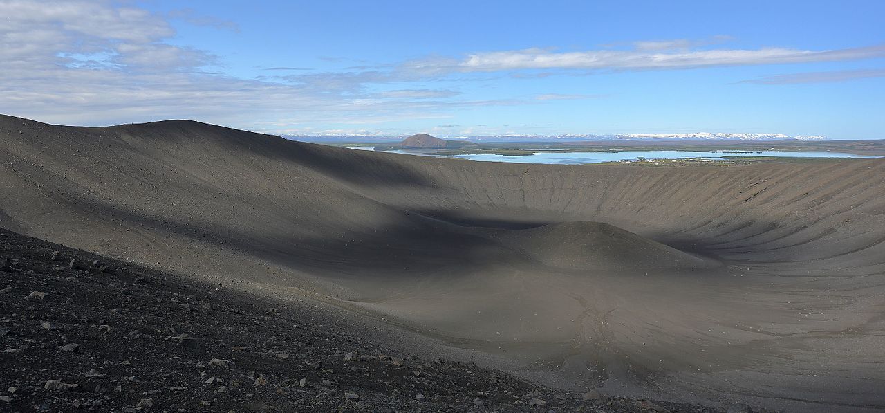
Hverfjall (also spelled Hverfell) is one of the world's most perfectly formed tephra cone craters. This massive volcanic crater near Lake Mývatn was created in a single explosive eruption approximately 2,700 years ago. Its nearly perfect circular shape and symmetrical rim make it a textbook example of a volcanic tephra cone.
Volcanic Features
Hverfjall's nearly perfect circular rim rises 170 meters above the surrounding lava fields. The dark tephra slopes contrast dramatically with the green Mývatn landscape, creating one of Iceland's most recognizable volcanic landmarks. Geologists from around the world visit this site to study one of the best-preserved tephra cones on Earth.
- Tephra cone (scoria cone) formed in single explosive eruption
- Diameter: ~1 km (1,000 meters)
- Crater depth: 140 meters
- Rim height: ~170 meters above surroundings
- Nearly perfect circular shape
- Part of Krafla volcanic system
- Visible from Route 1 (Ring Road)
How Hverfjall Formed
Hverfjall was created approximately 2,700 years ago in a violent phreatomagmatic eruption when rising magma met groundwater near Lake Mývatn. The water flashed to steam, creating a massive explosion that fragmented the magma into tiny particles (tephra/scoria) and blasted them into the air.
The volcanic fragments fell back around the vent in a circular pattern, building up the cone symmetrically layer by layer during the eruption. When the eruption ended, it left behind a deep crater surrounded by a nearly perfect circular rim of loose volcanic tephra.
- Phreatomagmatic (water-magma interaction) origin
- Black basaltic tephra (scoria) — loose, unconsolidated material
- Single-eruption feature
- No lava flows produced — purely explosive
- Minimal erosion in 2,700 years
Hiking Hverfjall Crater
Hiking to the rim of Hverfjall offers spectacular 360° panoramic views of Lake Mývatn, lava fields, and the surrounding volcanic landscape. The complete rim circuit is approximately 3 km.
- Distance: 1 km round trip to rim (from parking area)
- Elevation gain: ~170 meters
- Time to rim: 30–45 minutes
- Difficulty: Moderate
- Rim walk: Additional 3 km loop (1–1.5 hours extra)
- North route: Shorter, steeper climb
- South route: Gentler grade, longer
- Views from rim: Lake Mývatn, Dimmuborgir, Krafla, Námafjall, distant mountains
Hiking Rules & Safety
- Do NOT hike inside the crater — strictly prohibited to protect fragile environment
- Stay on marked trails — loose tephra erodes easily
- Steep ascent — trail can be slippery
- Very windy on rim — hold onto children, secure loose items
- No shade — bring sun protection in summer
- Loose gravel — wear proper hiking boots
Nearby Attractions
- Dimmuborgir: 2 km — Lava formations and caves
- Grjótagjá cave: 3 km — Hot spring cave
- Lake Mývatn pseudocraters: 5 km — Skútustaðagígar
- Námafjall: 8 km — Geothermal area
- Krafla: 15 km — Víti crater and lava fields
- Mývatn Nature Baths: 10 km — Geothermal spa
Safety Information
Do not enter the crater — it is strictly prohibited. Stay on marked trails only. The ascent is steep and loose gravel can make it slippery. The rim is very exposed and windy. Wear sturdy hiking boots.