Eldgjá — Fire Chasm
The 934–940 AD eruption produced the largest lava flood in recorded history — 19.6 km³ of lava from a 40 km fissure
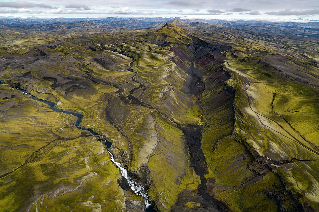
Eldgjá ('Fire Canyon') is a 40 km-long fissure associated with the Katla volcanic system. The eruption began around 934 and lasted about six years, making it the largest recorded effusive eruption. It produced the world's largest lava field of historic times and fundamentally shaped Iceland's landscape.
About the Volcanic System
Eldgjá is part of the Katla volcanic system in southern Iceland. The fissure extends 75 km in total, reaching 270 meters deep at its lowest point and 600 meters wide in places. It is located between Landmannalaugar and Kirkjubæjarklaustur.
- Part of the Katla volcanic system
- 40 km-long fissure (extends 75 km total)
- Located in southern Iceland highlands
- Connected to Mýrdalsjökull glacier
- Elevation: 600–800 m above sea level
- Deepest point: 270 m below rim
- Width: up to 600 m in places
The Great Eruption of 934–940 AD
The Eldgjá eruption began around 934 AD and continued for approximately six years, producing the largest effusive eruption in recorded history and significantly impacting medieval Iceland. The total lava volume of 19.6 km³ makes this the largest effusive eruption in recorded history.
The eruption is documented in medieval Icelandic sagas and chronicles. Ice core data from Greenland confirms the massive sulfur dioxide emissions (producing sulphuric aerosols), and the eruption contributed to significant climate cooling and crop failures across the Northern Hemisphere during the 10th century.
- 934 AD: Initial explosive activity opens the 40 km-long fissure system
- 934–936 AD: Enormous lava effusion phase produces 19.6 km³ total
- 936–938 AD: Continued effusion generates massive sulphuric aerosols affecting Northern Hemisphere climate
- 938–940 AD: Final intermittent explosive and effusive episodes
- 940 AD: Eruption ceases after approximately six years
Environmental Impact
- Climate cooling in Northern Hemisphere
- Sulfur emissions detected in Greenland ice cores
- Possible crop failures in Europe
- Atmospheric haze documented
- Massive landscape transformation in Iceland
- Rivers diverted by lava flows
- Highland grazing areas destroyed
- Settlement patterns permanently changed
Geological Features
Eldgjá represents one of the most spectacular examples of fissure eruption geology. The site includes deep volcanic chasms, multiple crater rows, lava channels and tubes, rootless cones (pseudocraters), several crater lakes, and seasonal waterfalls.
Eldgjá provides crucial insights into large-scale basaltic fissure eruptions and their environmental impacts. The site serves as an analog for understanding similar prehistoric eruptions and helps scientists assess the potential impacts of future large-scale volcanic events.
Visiting Eldgjá
Eldgjá is located in Iceland's remote central highlands. Access requires careful planning, 4WD vehicles, and highland driving experience. The most popular trail leads to Ófærufoss, a stunning two-tiered waterfall inside the canyon — about 4 km round trip.
The main access routes are F-208 and F-235, open June to September. July and August offer the most stable weather; late August brings stunning autumn colors.
- F208: Main highland route (4WD vehicle essential)
- F235: Alternative access route
- River crossings required
- Season: June–September
- Key highlight: Ófærufoss waterfall inside the canyon
- Guided highland tours recommended
Safety Information
Eldgjá is in a remote highland area. Bring a 4WD with high clearance, spare tires, GPS navigation, emergency food and water, and weather-appropriate clothing. Check road conditions at road.is before departure.