Eyjafjallajökull
The Volcano That Stopped the World
This ice-capped stratovolcano became globally famous in 2010 when its eruption produced an ash cloud that disrupted air travel worldwide for weeks. The name means "Island Mountain Glacier."
Volcano-Glacier
- Stratovolcano completely covered by glacier
- Active volcanic system
- Ice-magma interaction creates explosive eruptions
- Part of the Southern Iceland volcanic zone
Ice Cap Facts
- Area: ~100 km²
- Covers entire volcanic crater
- Multiple outlet glaciers
- Ice thickness: up to 200m
Location
- South Iceland, visible from Ring Road
- 25 km west of Katla volcano
- 120 km from Reykjavík
- Overlooks coastal plains
A Glacier-Capped Giant
Eyjafjallajökull rises 1,651 meters above the south coast, its ice-capped summit visible for miles across the coastal plains. The name translates to "Island Mountain Glacier," referring to the Westman Islands visible offshore.
Beneath the serene ice cap lies one of Iceland's most active volcanic systems, where the interaction between fire and ice creates some of nature's most explosive phenomena.
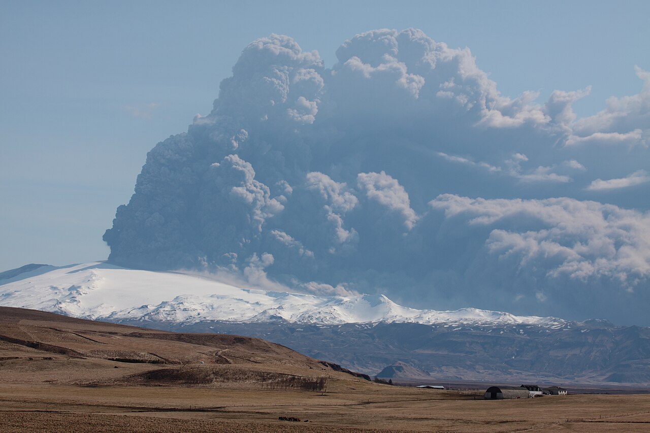
The 2010 Eruption — Global Impact
The 2010 eruption created the largest air-traffic shutdown since World War II, affecting 10 million passengers, with 100,000 flights cancelled and economic losses of $1.7 billion due to fine volcanic ash in the atmosphere.
- March 20, 2010 — Fimmvörðuháls: Initial eruption began on the flank, creating spectacular lava fountains. This effusive eruption lasted 3 weeks.
- April 14, 2010 — Summit Eruption: Main explosive eruption began under the ice cap, creating massive ash clouds that rose 11 km into the atmosphere and spread across Europe.
- Global Shutdown: European airspace closed for 6 days — the most comprehensive flight ban in peacetime history.
- Why so disruptive: Ice-magma interaction created fine ash that damages jet engines; westerly winds carried ash to Europe.
- Local impact: Glacial floods (jökulhlaups), ash fall on farmland, temporary evacuation of areas, and a subsequent tourism boom.
The Ice Cap Today
Post-eruption, the glacier has reformed over the volcanic crater, though the ice cap is smaller and changed by the 2010 events.
- Ice reformed over crater since 2010
- Thinner ice cap than pre-eruption
- New crevasse patterns
- Ongoing glacial retreat due to climate change
- 24/7 volcanic monitoring with seismic stations, regular ice thickness measurements, and GPS tracking of ground deformation
- Gígjökull: famous outlet glacier with lagoon; Steinholtsjökull: popular for hiking
Visiting Eyjafjallajökull
- Best viewpoints: Ring Road (multiple spots), Þórsmörk at the base, Seljavallalaug historic pool, Skógafoss waterfall with volcano backdrop
- Hiking options: Fimmvörðuháls trail (challenging), Þórsmörk day hikes, Steinholtsjökull glacier walk, summit climb (expert only)
- Nearby attractions: Skógafoss and Seljalandsfoss waterfalls, black sand beaches at Reynisfjara, Þórsmörk nature reserve, Westman Islands
- Visitor center: The Eyjafjallajökull Erupts visitor center near Hvolsvöllur tells the story of the 2010 eruption with multimedia exhibits
Safety Information
Eyjafjallajökull is an active volcano. Never attempt glacier or summit access without certified guides. Monitor volcanic activity at Veðurstofa.is and check safetravel.is before visiting. Jökulhlaup flood evacuation routes are signposted on the south coast.